3D atlas of China published
chinaplus.cri.cn |
Updated: 2018-08-17 10:33


Share


Share - WeChat


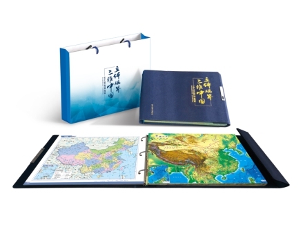
The first 3D atlas of China has been published by Harbin Cartographic Publishing House, the Science and Technology Daily reported on Wednesday.
The publisher has used a unique optical grating material to print some of the map images. The result is that the maps have a 3D appearance when looked at with the naked eye. The atlas provides data on transportation systems, tourists sites, and historical areas around China.


- Pact to boost China's gold market
- Annual lantern festival opens in Shanghai
- Work teams dispatched after earthquake hits Diebu county in Gansu
- Zhangjiajie National Forest Park transforms into a winter paradise
- Thousands enjoy freshly cooked laba porridge in Sichuan
- Short videos highlight the beauty of Hebei